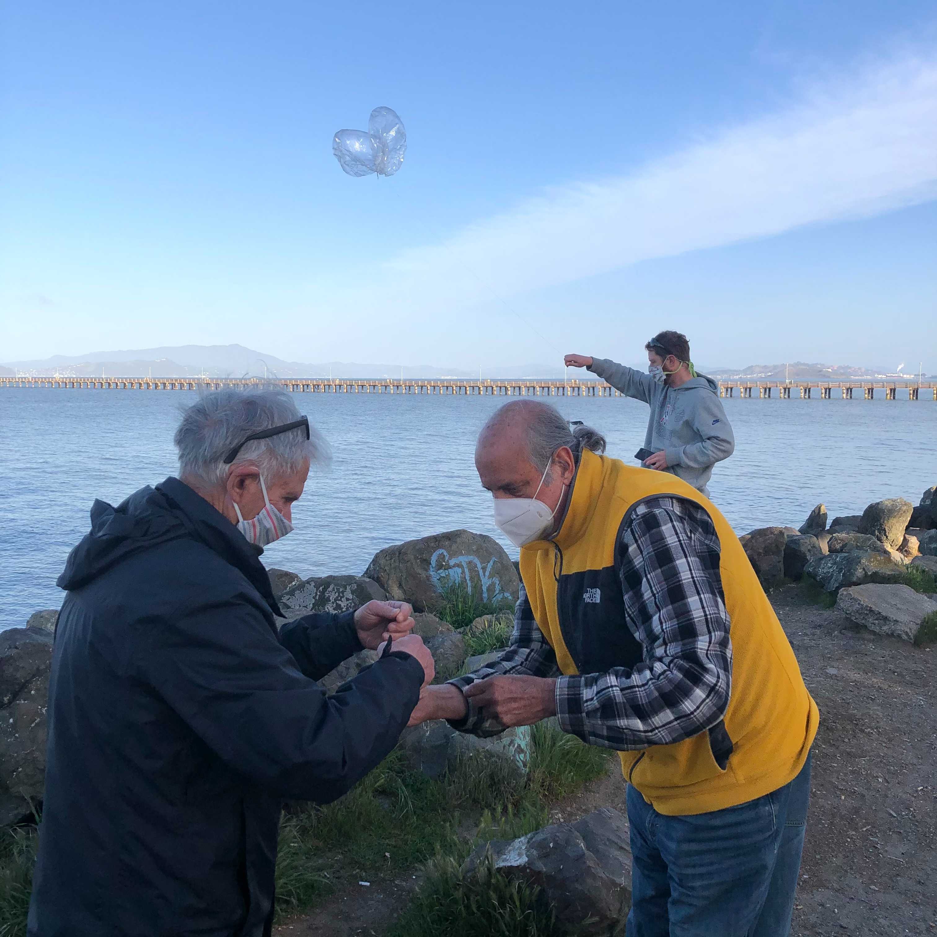
On the morning of Saturday April 10, 2021, members of the San Francisco High Altitude Balloon group launched another picoballoon from the Berkeley Marina. Launch location was the south tip of Shorebird Park, and the launch party was Martin W6MRR, Robert K6RGG, Peter W6DEI, and myself.
Balloon Hardware
The hardware was very similar to the previous launch. The one big change this time was that the APRS 144.39 MHz transmitter was removed. This 500 mW transmitter took a lot of power, and sometimes RFI would lock the processor up bad enough that the balloon needed to power off completely before it would reset. The only transmitter on this balloon was WSPR on 14.0956 MHz.
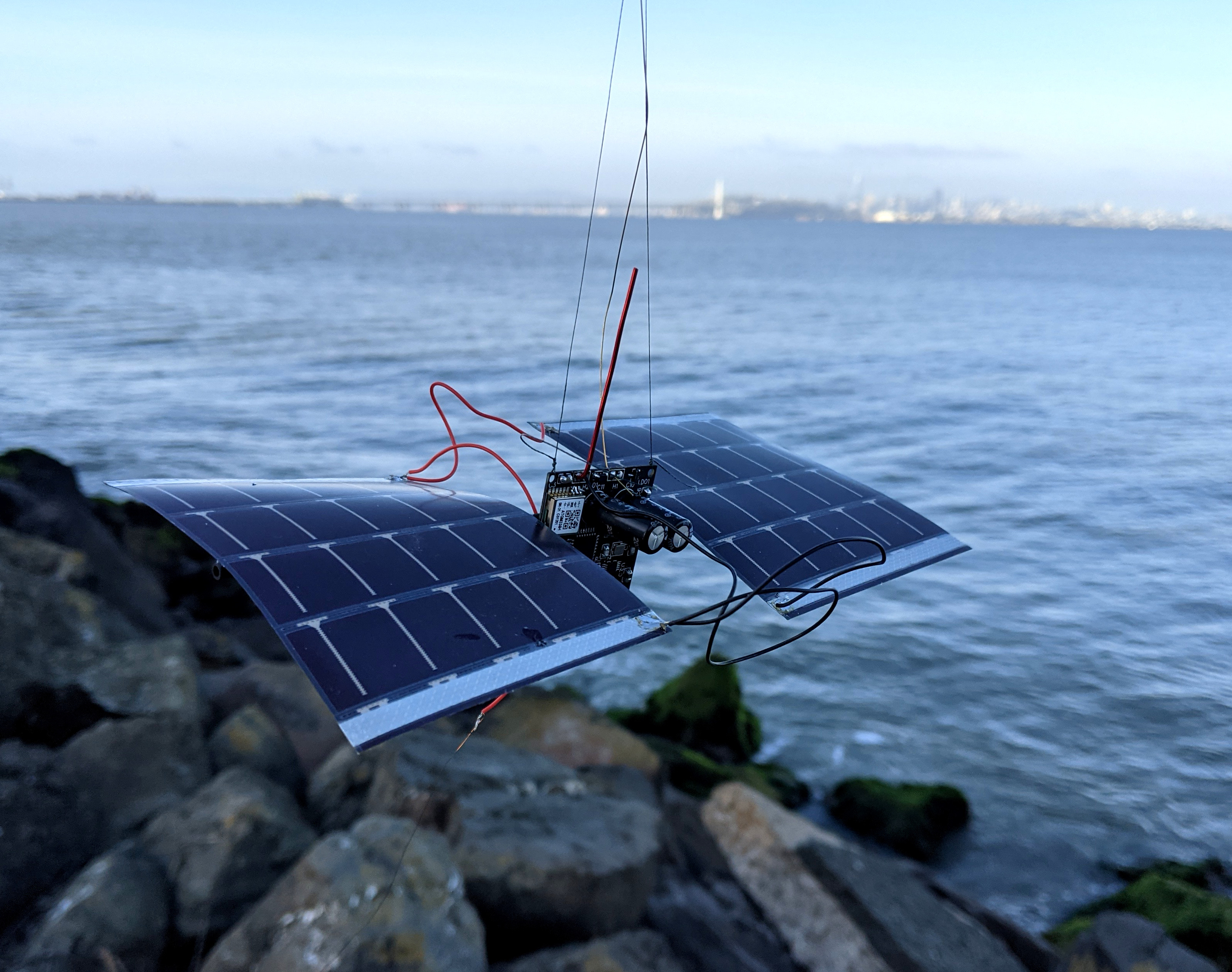
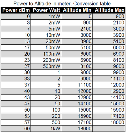
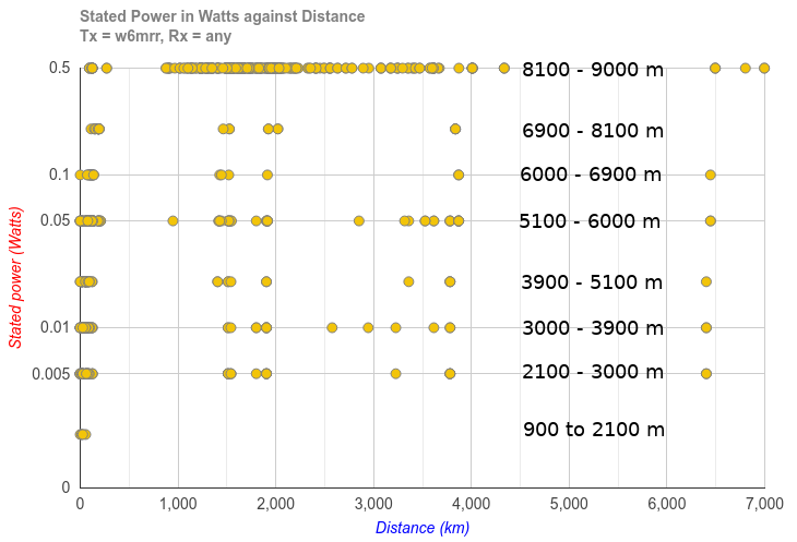
Output power of WSPR transmitter is only 10 mW. Since the WSPR protocol only includes a Maidenhead gridsquare and not altitude, we encoded the altitude using the Power field in the WSPR protocol. This is described more by ZachTek (PDF). This chart shows the different Power values corresponding to the altitude bands.
Software
The ground software to post the WSPR packet on the APRS network (and have it show up on aprs.fi) is the aprsWsprBrige python script written by Graham VE3GTC. This script scrapes the WSPR database for a particular callsign and uploads the gridsquare location to the APRS network.
Installation was very simple following the installation instructions in the aprsWsprBridge_notes.txt file. I'm running the script every 15 minutes on odd minutes, which reduces load on the WSPR servers. wspr_spotsLog.txt is a log of the WSPR spots downloaded from the WSPR database. log.txt is a running log of what the program is doing, and is helpful to watch to make sure it's working.
One thing to note is the script converts the Maidenhead gridsquare to lat/long for APRS, but puts the lat/long location in the bottom left corner of the gridsquare. So the balloon could be up to 1 degree North or 2 degrees East of the APRS location. The WSPR maps below put the balloon in the center of the gridsquare.
The APRS callsign for this balloon was W6MRR-14.
Launch
The launch went smoothly. It took us about 15 minutes to charge the supercaps and make sure the electronics were working, attach the two pre-filled balloons to the upper dipole antenna, unroll the both halves of the dipole, and release it. The wind was gusting up to 4 MPH, so we waited until the gust died before releasing it. Thanks to Robert K6RGG for these pictures.


Flight Data
Launch was just after 1500 UTC (8am Local time) on Saturday April 10th. Even though the supercaps were completely charged up before launch via USB, there still wasn't enough sunlight on the solar cells to transmit its position.
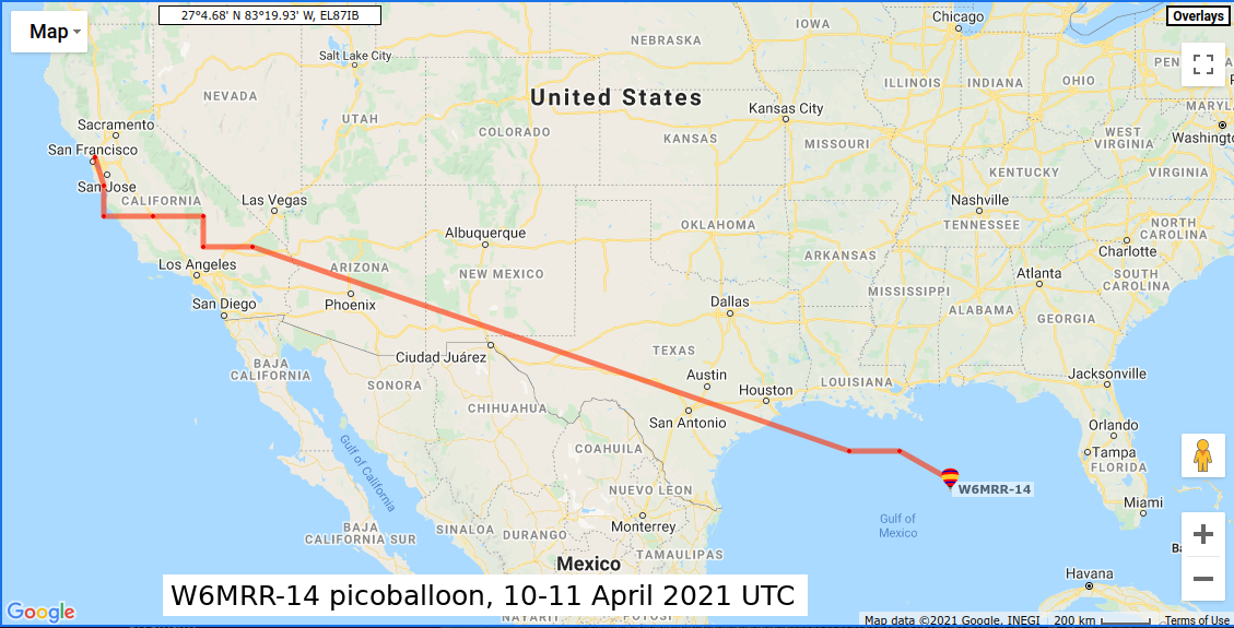
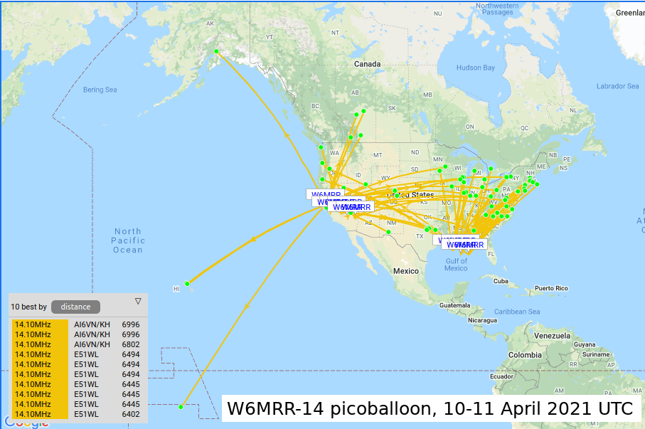
On the first day, the first packet was received just over an hour after launch at 1606 UTC. A total of 58 packets were transmitted from the balloon in 7 gridsquares across California. It took 4.5 hours for the balloon to rise from sea level up to 8100 meters (~26,500 feet), for an average ascent rate of about 0.5 meters/sec (1.5 feet/sec). At 2256 UTC, the balloon sent its last transmission near Las Vegas as night fell.
On Sunday April 11th, the balloon woke up at 1338 UTC over the Gulf of Mexico, south of Louisiana. It had flown ~2350 km (~1460 miles) overnight, for an average speed ~160 km/hr (~100 MPH). The altitude was still around 8500 meters (~28,000 feet). Only 15 packets were received this day, from 4 gridsquares, and all transmissions ceased at 1528 UTC.
It was only alive on Sunday for about 2 hours. We'll never know what it stopped transmitting; maybe there was a layer of high clouds that reduced solar power? Or a thunderstorm downdraft pushed the balloon into the ocean? Or it was raining and water froze on the balloon or shorted the electronics? We'll never know, and there is no chance of recovering these picoballoons for an investigation.
Looking at the WSPR data in map form, the furthest WSPR packet was received on Saturday by E51WL from the island of Penrhyn in the North Cooks Islands. ~6500 km (~4000 miles) with 10 mW of power is pretty awesome!
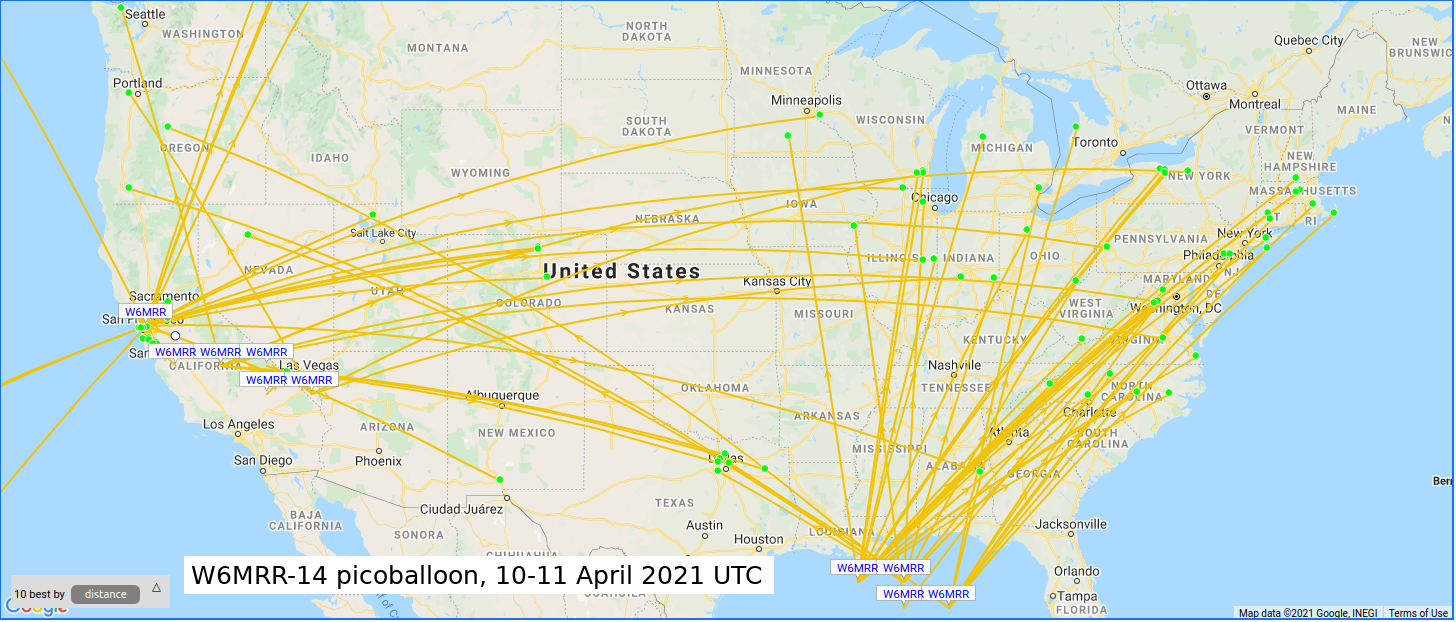
Zooming in on just the United States, we can see that most of the packets on Saturday were received in the United States. Since the 20 meter (14 MHz) amateur radio band is a daytime band, this makes sense. Sunday packets were received across the East Coast of the US, where it was daytime at the time those packets were transmitted.
Here's an interesting chart of Power (altitude) vs. Distance. Remember that "Power" on this graph is not actually power, the transmitter is always putting out 10 mW. The "Power" field corresponds altitude, from the chart above. I have labeled on the chart on the right side with these altitude marks. Since the actual power is constant, this chart shows that when the band is open, even 10 mW will get your signal thousands of miles.
All of the WSPR data is saved in a spreadsheet here. We plan on launching more balloons soon!