The next Saturday after the third launch, Martin W6MRR, Robert K6RGG, and Rob NZ6J got together at the Berkeley Marina and launched another picoballoon. I was away on a much-needed vacation.
Since the last launch didn't get above 9000 meters, Martin spent extra time measuring the payload and lift of the balloon. To go around the world, it's important that the balloon has enough lift to rise above weather that may push the balloon down, or coat it with water or ice.
Here's the mass breakdown of this balloon, with the same tracker electronics as the previous launch:
| Item | Mass | |
|---|---|---|
| 2 solar cells & carbon fiber stick | 5 g | |
| Beacon PCB w/supercaps | 7 g | |
| Upper wire | 1.5 g | |
| Lower wire | 0.9 g | |
| Total payload | 15.24 g |
The two balloons weighed 71 grams, and after filling with hydrogen had a net neck lift of 23 grams, for a total free lift of 8 grams. This lift should give the balloon a final altitude of 11,500 meters (~38,000 ft), which is above any weather.

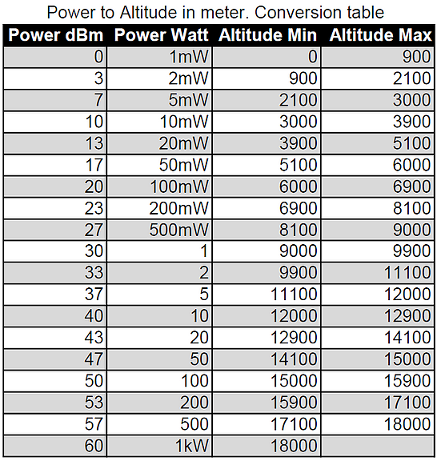
Since longevity of the balloon is directly related to flight altitude, we were closely watching the reported altitude. Since the WSPR packet structure assumes the transmitting station is on the ground, the picoballoon community has re-purposed the "Power" field as a proxy for altitude using the chart below. Actual TX power from the balloon is only 10 mW, or +10 dBm, into a vertically-polarized dipole.
Flight Data
The APRS callsign for this balloon was W6MRR-15. Using the aprsWsprBridge.py script, I accidentally put the last position of W6MRR-14 onto the map in the Gulf of Mexico, so just disregard that position. I have photoshopped that point out in this graphic.

VK7JJ provides a nice map of the WSPR data, as well as various graphs and statistics. Here is a map of all the stations that received the balloon during flight. Note that only the first received packet is shown on this map.
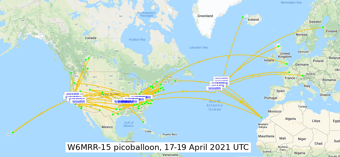
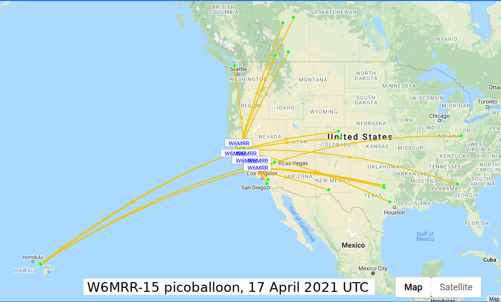
On Saturday April 17th, launch occurred just after 1500 UTC (8am local time). The first WSPR packet was received just over an hour later at 1606 UTC, and a total of 60 packets were received, with the last packet transmitted at 2336 UTC (4:30pm local time). At this point, the balloon altitude was between 9000 and 9900 meters (~29,500 to 32,500 ft), and it had drifted 500 km south from Berkeley, California to the DM04 grid, just north of Los Angeles.
On Sunday April 18th, the balloon woke up at 1436 UTC (9:36am local time) in the middle of Arkansas, after sleeping for 15 hours and traveling approximately 2200 km. Overnight the altitude dropped just below 9000 meters (~29,500 ft). Over the day, it floated just around the 9000 meter mark and drifted northeast at a speed around 200 km/hr (125 MPH). A total of 71 WSPR packets were received, with the last transmission at 2108 UTC over the northwest corner of North Carolina.
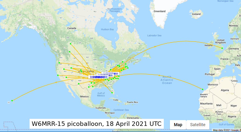
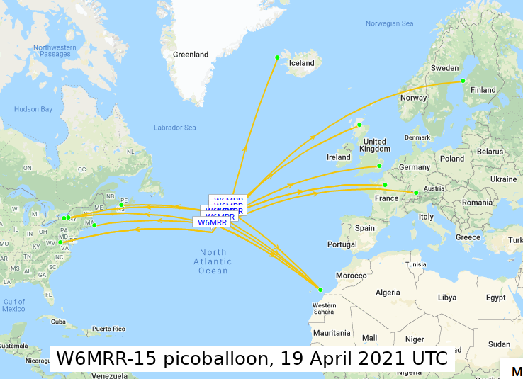
The balloon slept for 16 hours, traveling over 3500 km at a speed of 220 km/hr (135 MPH), and woke up on April 19th at 1306 UTC over the middle of the Atlantic Ocean. Only 14 packets were received this day. This is very interesting because most of the individual WSPR packets were only received by a single station. The previous day, as you can see in the map above, each packet was received by multiple stations, all up and down the East Coast. 20 meters (14 MHz) is a daytime band, and there are not a whole lot of stations in the daytime in the middle of the ocean.
Overall, this balloon flight was a great success. The tracker electronics woke up twice after a very cold overnight, proving that the electronics design is mature. Unfortunately, the balloon didn't even get close to the target altitude of 11,500 meters (~38,000 feet), which was a big disappointment. Since we've proven that the electronics work, this is the next area we are focusing on.
All of the WSPR data is saved in a spreadsheet here. The furthest WSPR packet received was by AI6VN/KH6 in Hawaii (gridsquare BL10rx), who received a packet from the balloon in South Carolina (gridsquare EM96). Over 7300 km (~4500 miles) away, with only 10 mW of transmit power! The band was definitely open at that time.